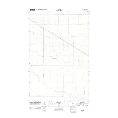
2013 Map of Swift
USGS Topo · Published 2013About this map
Swift sits along the MN-11 corridor in northern Roseau County, serving as a focal point in a landscape defined by organized drainage and forest access. This region illustrates the intersection of mid-century infrastructure and the wilderness, where the County Ditch Number Twenty and County Ditch Number Twentysix have long shaped the low-lying terrain for local use. To the south, the winding course of the E Br Warroad River cuts through the forest, crossed by the Scifres Bridge. The map details a network of rural routes and specialized paths like Tangnes Trl and Cranes Nest Rd, which provide access to Browns Lake and the Erickson Airport. These features highlight the area's dual character as both a remote recreational timberland and a surveyed agricultural frontier.
Find a feature on this map
22 named features on this map. Tap any name to fly to it.
Don’t see what you’re looking for? This feature index may not catch every label — zoom into the map to look around manually.
Map Details
Editions of this 2013 Swift Map
This is the sole edition of this map. No revisions or reprints were ever made.
Other maps of this area

1918 · Winterroad
USGS Topo · 1:62,500

1918 · Roosevelt
USGS Topo · 1:62,500

1918 · Warroad
USGS Topo · 1:62,500

1943 · Roosevelt
USGS Topo · 1:62,500

1943 · Warroad
USGS Topo · 1:62,500

1954 · Roseau
USGS Topo · 1:250,000

1957 · Roseau
USGS Topo · 1:250,000

1958 · Roseau
USGS Topo · 1:250,000

1967 · Roosevelt NW
USGS Topo · 1:24,000
1967 · Roosevelt
USGS Topo · 1:24,000