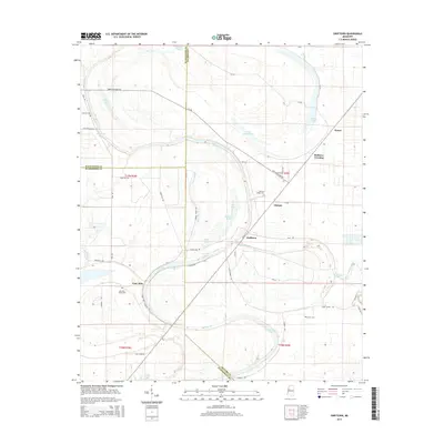
2015 Map of Swiftown
USGS Topo · Published 2015About this map
The low-lying Yazoo-Mississippi Delta is defined by a dense network of slow-moving water and oxbow lakes, including Bee Lake, Macon Lake, and Wasp Lake. Settled at the intersection of Leflore Co, Sunflower Co, and Humphreys Co, the landscape is a patchwork of rural holdings connected by local routes like Mother In Law Rd and Rabbit Ridge Rd. Small settlements such as Swiftown, Nichols, and Peteet serve as local anchors for this agricultural region, where the winding course of Bear Creek and Black Democrat Bayou dictate the layout of fields and roads.
Find a feature on this map
61 named features on this map. Tap any name to fly to it.
Don’t see what you’re looking for? This feature index may not catch every label — zoom into the map to look around manually.
Map Details
Editions of this 2015 Swiftown Map
This is the sole edition of this map. No revisions or reprints were ever made.
Other maps of this area

1940 · Auter
USGS Topo · 1:62,500

1940 · Baird
USGS Topo · 1:62,500

1940 · Mileston
USGS Topo · 1:62,500

1953 · Greenwood
USGS Topo · 1:250,000

1954 · Mileston
USGS Topo · 1:62,500

1956 · Greenwood
USGS Topo · 1:250,000

1961 · Mossy Lake
USGS Topo · 1:62,500

1965 · Inverness
USGS Topo · 1:24,000
1965 · Bellewood
USGS Topo · 1:24,000

1967 · Baird
USGS Topo · 1:62,500