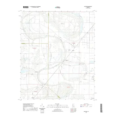
2020 Map of Swiftown
USGS Topo · Published 2020About this map
Swiftown and the surrounding Yazoo-Mississippi Delta lowlands are defined by a complex network of bayous, brakes, and oxbow lakes. The community of Jaketown sits in the southern portion of the map, while Four Mile and Nichols anchor the central corridor. This modern survey reveals a landscape still heavily influenced by its alluvial history, with large natural features like Mossy Island and Bee Lake shaping the local geography. Several cemeteries, including Sky Lake Bend Cem and Graves Cem, are scattered across the quadrangle, offering points of interest for genealogists tracing local families. The winding course of Bear Cr and the presence of wetlands like Paxton Brake and Beaver Dam Brake illustrate the persistent importance of water management and drainage in this agricultural region at the junction of Leflore, Sunflower, and Humphreys counties.
Find a feature on this map
59 named features on this map. Tap any name to fly to it.
Don’t see what you’re looking for? This feature index may not catch every label — zoom into the map to look around manually.
Map Details
Editions of this 2020 Swiftown Map
This is the sole edition of this map. No revisions or reprints were ever made.
Other maps of this area

1940 · Auter
USGS Topo · 1:62,500

1940 · Baird
USGS Topo · 1:62,500

1940 · Mileston
USGS Topo · 1:62,500

1953 · Greenwood
USGS Topo · 1:250,000

1954 · Mileston
USGS Topo · 1:62,500

1956 · Greenwood
USGS Topo · 1:250,000

1961 · Mossy Lake
USGS Topo · 1:62,500

1965 · Inverness
USGS Topo · 1:24,000
1965 · Bellewood
USGS Topo · 1:24,000

1967 · Baird
USGS Topo · 1:62,500