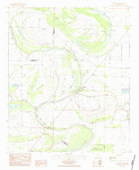
1983 Map of Swiftown
USGS Topo · Published 1984About this map
Swiftown stands at the heart of a complex network of oxbow lakes and winding waterways in this low-lying Delta landscape. The area is defined by the remnants of former river paths, including Sixmile Lake, Fourmile Lake, and Bee Lake, which wrap around Mossy Island. A distinctive historical marker, the Indian Treaty Boundary, cuts diagonally across the lower half of the quadrangle, tracing a legacy of land division north of Wasp Lake. The map reveals a community structured around rural spiritual and memorial sites, such as Bethlehem Ch and Hickory Ridge Cem. Economic activity in the early 1980s is reflected in the specialized use of the wetlands, notably at the Fish Hatchery and within the Greentree State Waterfowl Production Area south of Beckham Swamp.
Find a feature on this map
47 named features on this map. Tap any name to fly to it.
Don’t see what you’re looking for? This feature index may not catch every label — zoom into the map to look around manually.
Map Details
Editions of this 1983 Swiftown Map
This is the sole edition of this map. No revisions or reprints were ever made.
Other maps of this area

1940 · Auter
USGS Topo · 1:62,500

1940 · Baird
USGS Topo · 1:62,500

1940 · Mileston
USGS Topo · 1:62,500

1953 · Greenwood
USGS Topo · 1:250,000

1954 · Mileston
USGS Topo · 1:62,500

1956 · Greenwood
USGS Topo · 1:250,000

1961 · Mossy Lake
USGS Topo · 1:62,500

1965 · Inverness
USGS Topo · 1:24,000
1965 · Bellewood
USGS Topo · 1:24,000

1967 · Baird
USGS Topo · 1:62,500