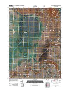
2011 Map of Sycan Marsh East
USGS Topo · Published 2011About this map
Brattain Ranch and the ZX Ranch anchor this landscape in Lake County, Oregon, where the high desert terrain transitions into the expansive wetlands of the Sycan Marsh. This area is defined by its complex hydrology, with the winding Sycan River and numerous tributaries such as Chocktoot Creek, Shake Creek, and Coyote Creek feeding the marshy basin. To the north, the elevation rises sharply along Brattain Ridge and reaches its peak at Sycan Butte, where the Sycan Butte Lookout provides a strategic vantage point overlooking the surrounding valley. The drainage patterns of Squaw Creek and the North Fork Chocktoot Creek illustrate the water-driven geography of this ranching country. The presence of Louse Lake in the southeast corner further highlights the diverse aquatic features that have historically supported the region's large-scale cattle operations.
Find a feature on this map
17 named features on this map. Tap any name to fly to it.
Don’t see what you’re looking for? This feature index may not catch every label — zoom into the map to look around manually.
Map Details
Editions of this 2011 Sycan Marsh East Map
This is the sole edition of this map. No revisions or reprints were ever made.
Other maps of this area

1889 · Klamath
USGS Topo · 1:250,000

1894 · Klamath
USGS Topo · 1:250,000

1955 · Klamath Falls
USGS Topo · 1:250,000

1958 · Klamath Falls
USGS Topo · 1:250,000

1960 · Riverbed Butte
USGS Topo · 1:62,500

1960 · Sycan Marsh
USGS Topo · 1:62,500

1966 · Shake Butte
USGS Topo · 1:24,000

1966 · Pole Butte
USGS Topo · 1:24,000

1966 · Foster Butte
USGS Topo · 1:24,000

1974 · Lake Abert
USGS Topo · 1:100,000