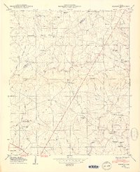
1950 Map of Sylvania
USGS Topo · Published 1950About this map
Sand Mountain dominates this mid-century landscape of DeKalb County, Alabama, where a network of crossroads communities defines the local geography. The central settlement of Sylvania is surrounded by rural hubs such as Bowman Crossroads, Brooks Crossroads, and Mahan Crossroads, each connected by a winding system of roads that navigate the headwaters of South Sauty Creek and Bengis Creek. The map reveals a dense social infrastructure of small churches and family burial grounds, including Unity Ch, Happy Home Church, and the Mahan Cem. This survey, based on 1947 field examinations by the Tennessee Valley Authority, details the intricate drainage patterns of the plateau, where numerous branches like Pole Bridge Branch and Wolf Branch carve into the terrain. The presence of landmarks like Wilkes Store and Double Spring highlights the importance of specific local points of trade and natural resources for the residents of Frog Valley and the surrounding tableland.
Find a feature on this map
63 named features on this map. Tap any name to fly to it.
Don’t see what you’re looking for? This feature index may not catch every label — zoom into the map to look around manually.
Map Details
Editions of this 1950 Sylvania Map
2 editions found
Other maps of this area

1886 · Stevenson
USGS Topo · 1:125,000

1892 · Stevenson
USGS Topo · 1:125,000

1893 · Fort Payne
USGS Topo · 1:125,000

1895 · Stevenson
USGS Topo · 1:125,000

1898 · Fort Payne
USGS Topo · 1:125,000

1900 · Fort Payne
USGS Topo · 1:125,000

1936 · Ider
USGS Topo · 1:24,000

1936 · Dugout Valley
USGS Topo · 1:24,000

1936 · Chavies
USGS Topo · 1:24,000

1936 · Dutton
USGS Topo · 1:24,000