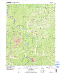
1996 Map of Sylvester
USGS Topo · Published 2002About this map
The Big Coal River carves a winding path through this portion of the Sherman district, anchoring a landscape defined by coal extraction and narrow valley settlements. Small communities like Seth, Fosterville, Coopertown, and Orgas are strung along the riverbanks, where the topography forces infrastructure into tight corridors. This mid-1990s data reveals the heavy industrial footprint of the region, marked by numerous Strip Mine operations and a sophisticated Conveyor system designed to transport resources across the steep terrain.
Find a feature on this map
54 named features on this map. Tap any name to fly to it.
Don’t see what you’re looking for? This feature index may not catch every label — zoom into the map to look around manually.
Map Details
Editions of this 1996 Sylvester Map
This is the sole edition of this map. No revisions or reprints were ever made.
Other maps of this area

1891 · Oceana
USGS Topo · 1:125,000

1891 · Raleigh
USGS Topo · 1:125,000

1893 · Oceana
USGS Topo · 1:125,000

1897 · Kanawha Falls
USGS Topo · 1:125,000

1897 · Raleigh
USGS Topo · 1:125,000

1898 · Oceana
USGS Topo · 1:125,000

1899 · Charleston
USGS Topo · 1:125,000

1900 · Kanawha Falls
USGS Topo · 1:125,000

1901 · Kanawha Falls
USGS Topo · 1:125,000

1902 · Raleigh
USGS Topo · 1:125,000