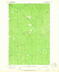
1963 Map of Sylvia Lake
USGS Topo · Published 1966About this map
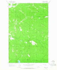
The Lincoln Co Flathead Co boundary cuts through this high-country landscape, where the Kootenai National Forest meets the Flathead National Forest. This 1963 field-checked survey reveals a remote backcountry defined by steep ridges and fire-watch infrastructure, most notably the Lookout Tower atop Ingalls Mountain. Central to the quadrangle is Sylvia Lake, situated near a small Roadside Park, serving as a rare point of developed access in a region otherwise navigated by an extensive network of Pack Trail routes. These trails follow the drainages of Sheppard Creek, Ingalls Creek, and the South Fork Hand Creek, providing a detailed look at the montane environment before more modern road development reached these higher elevations. The map also identifies prominent peaks including Mount Conner, Sanders Mountain, and Grubb Mountain.
Find a feature on this map
21 named features on this map. Tap any name to fly to it.
Don’t see what you’re looking for? This feature index may not catch every label — zoom into the map to look around manually.
Map Details
Editions of this 1963 Sylvia Lake Map
3 editions found
Other maps of this area

1957 · Kalispell
USGS Topo · 1:250,000

1960 · Kalispell
USGS Topo · 1:250,000

1961 · Kalispell
USGS Topo · 1:250,000

1962 · Johnson Peak
USGS Topo · 1:24,000

1962 · Ashley Mountain
USGS Topo · 1:24,000

1963 · Sylvia Lake
USGS Topo · 1:24,000
1963 · Bowen Lake
USGS Topo · 1:24,000
1963 · Dunsire Point
USGS Topo · 1:24,000
1963 · Horse Hill
USGS Topo · 1:24,000
1964 · Pleasant Valley Mountain
USGS Topo · 1:24,000