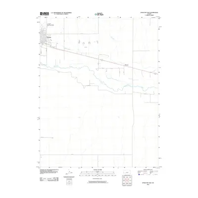
2010 Map of Syracuse East
USGS Topo · Published 2010About this map
The Syracuse townsite anchors the northwestern corner of this Kansas landscape, where the local street grid including Sumner St and Barton St meets the open agricultural plains. The Arkansas River meanders across the center of the quadrangle, flanked by irrigation infrastructure like the Fort Aubrey Ditch, which signals the intensive water management required for farming in Hamilton County. To the east, the small settlement of Mayline sits along the primary highway corridor, serving as a localized waypoint in an area otherwise defined by a sparse network of section-line roads such as Rd 20 and Rd O. Aviation activity is centered at the Syracuse- Hamilton County Municipal Airport north of town, while the southern reaches of the map remain largely undeveloped, characterized by the seasonal drainage of Sand Creek and the long, straight stretch of E River Rd.
Find a feature on this map
20 named features on this map. Tap any name to fly to it.
Don’t see what you’re looking for? This feature index may not catch every label — zoom into the map to look around manually.
Map Details
Editions of this 2010 Syracuse East Map
This is the sole edition of this map. No revisions or reprints were ever made.
Other maps of this area

1900 · Syracuse
USGS Topo · 1:125,000

1920 · Syracuse
USGS Topo · 1:125,000

1955 · Dodge City
USGS Topo · 1:250,000

1955 · Scott City
USGS Topo · 1:250,000

1958 · Dodge City
USGS Topo · 1:250,000

1958 · Scott City
USGS Topo · 1:250,000

1959 · Dodge City
USGS Topo · 1:250,000

1966 · Syracuse East SW
USGS Topo · 1:24,000

1966 · Syracuse East
USGS Topo · 1:24,000
1966 · Syracuse West SE
USGS Topo · 1:24,000