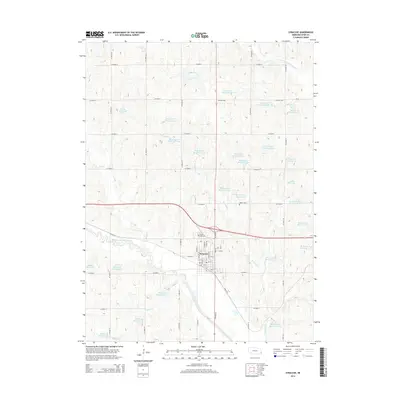
2014 Map of Syracuse
USGS Topo · Published 2014About this map
The Syracuse community serves as the primary hub of this 2014 Otoe County landscape, situated at the convergence of the Little Nemaha River and Brownell Cr. The map reveals a highly managed drainage system characterized by dozens of flood control and agricultural impoundments, including the Chase Hoppe Reservoir 9-A, Janeke Reservoir, and numerous numbered structures along the Ziegler Cr and Brownell Creek tributaries. This density of reservoirs illustrates the modern water management priorities of the Nebraska plains. Local history and genealogy interests are anchored by Park Hill Cem on the northern edge of the town site and the more isolated Warner Cem to the east. The terrain is defined by a grid of county roads, such as CO Road 30 and CO Road D, which navigate the elevation changes between the river valley and the surrounding agricultural uplands.
Find a feature on this map
68 named features on this map. Tap any name to fly to it.
Don’t see what you’re looking for? This feature index may not catch every label — zoom into the map to look around manually.
Map Details
Editions of this 2014 Syracuse Map
This is the sole edition of this map. No revisions or reprints were ever made.
Other maps of this area

1903 · Weeping Water
USGS Topo · 1:125,000

1929 · Weeping Water
USGS Topo · 1:125,000

1955 · Lincoln
USGS Topo · 1:250,000

1957 · Lincoln
USGS Topo · 1:250,000

1958 · Lincoln
USGS Topo · 1:250,000
1966 · Dunbar
USGS Topo · 1:24,000
1966 · Avoca
USGS Topo · 1:24,000
1966 · Cook
USGS Topo · 1:24,000
1966 · Talmage
USGS Topo · 1:24,000
1966 · Elmwood
USGS Topo · 1:24,000