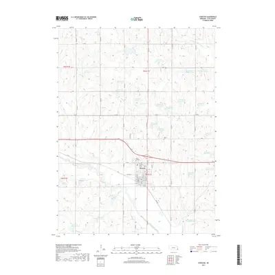
2017 Map of Syracuse
USGS Topo · Published 2017About this map
Syracuse serves as the primary hub of this Otoe County landscape, where the residential grid meets a complex network of agricultural management features. The town’s streets, including Mohawk St and Chestnut St, are concentrated south of where Highway 2 bisects the region. The surrounding prairie is defined by an extensive system of flood control and irrigation, evidenced by the high density of numbered reservoirs such as Brownell Cr Reservoir 11-A and Ziegler Cr Reservoir Z-16. This infrastructure follows the natural drainage of the Little Nemaha River and its various tributaries like Wolf Cr and the N Fork Little Nemaha River. Local genealogy and history are preserved at Park Hill Cem on the northern edge of the settlement and the more isolated Warner Cem to the northeast, marking the early burial grounds of the area's farming families.
Find a feature on this map
68 named features on this map. Tap any name to fly to it.
Don’t see what you’re looking for? This feature index may not catch every label — zoom into the map to look around manually.
Map Details
Editions of this 2017 Syracuse Map
This is the sole edition of this map. No revisions or reprints were ever made.
Other maps of this area

1903 · Weeping Water
USGS Topo · 1:125,000

1929 · Weeping Water
USGS Topo · 1:125,000

1955 · Lincoln
USGS Topo · 1:250,000

1957 · Lincoln
USGS Topo · 1:250,000

1958 · Lincoln
USGS Topo · 1:250,000
1966 · Dunbar
USGS Topo · 1:24,000
1966 · Avoca
USGS Topo · 1:24,000
1966 · Cook
USGS Topo · 1:24,000
1966 · Talmage
USGS Topo · 1:24,000
1966 · Elmwood
USGS Topo · 1:24,000