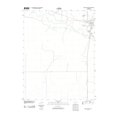
2010 Map of Syracuse West
USGS Topo · Published 2010About this map
The western edges of Syracuse are defined by a complex network of agricultural irrigation and water management systems. This high-plains landscape shows the Arkansas River winding through Hamilton County, flanked by crucial water-diversion infrastructure like the Fort Aubrey Ditch and Alamo Ditch. These man-made channels reflect the region's long-standing reliance on the river for local agriculture. The town's social and civic heart is visible through the Hamilton County Fairgrounds and the Syracuse Cemetery situated near the banks of Syracuse Creek. Further south, the terrain opens into a series of section-line roads, such as Co Rd 25 and Rd F, illustrating the classic grid-based settlement pattern of the Kansas plains. A Gaging Station on the river indicates the ongoing importance of monitoring the Arkansas River's flow for the surrounding community.
Find a feature on this map
19 named features on this map. Tap any name to fly to it.
Don’t see what you’re looking for? This feature index may not catch every label — zoom into the map to look around manually.
Map Details
Editions of this 2010 Syracuse West Map
This is the sole edition of this map. No revisions or reprints were ever made.
Other maps of this area

1900 · Syracuse
USGS Topo · 1:125,000

1920 · Syracuse
USGS Topo · 1:125,000

1955 · Dodge City
USGS Topo · 1:250,000

1955 · Scott City
USGS Topo · 1:250,000

1958 · Dodge City
USGS Topo · 1:250,000

1958 · Scott City
USGS Topo · 1:250,000

1959 · Dodge City
USGS Topo · 1:250,000

1966 · Syracuse West SW
USGS Topo · 1:24,000

1966 · Syracuse East SW
USGS Topo · 1:24,000
1966 · Tribune 3 SW
USGS Topo · 1:24,000