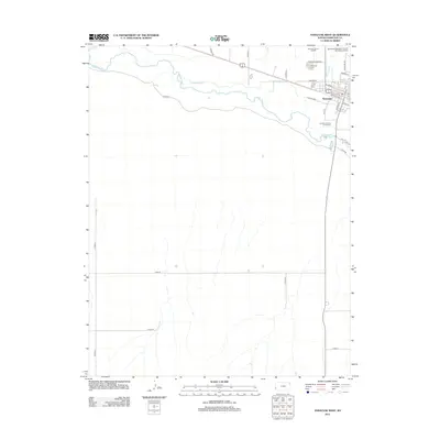
2012 Map of Syracuse West
USGS Topo · Published 2012About this map
Syracuse serves as the focal point of this 2012 survey, situated in Hamilton County along the northern bank of the Arkansas River. The landscape reveals a complex network of agricultural and municipal management, characterized by the Fort Aubrey Ditch irrigation system and local landmarks such as the Hamilton County Fairgrounds and the Syracuse-Hamilton County Municipal Airport. To the north and south of the river, the terrain is partitioned by a grid of county roads including Co Road J and Cord-27, indicating the persistent rural structure of Western Kansas. Genealogy and local history researchers can identify the locations of the Syracuse Cemetery and the local Post Office on N Main St, providing a clear record of the community's infrastructure at the start of the 2010s.
Find a feature on this map
28 named features on this map. Tap any name to fly to it.
Don’t see what you’re looking for? This feature index may not catch every label — zoom into the map to look around manually.
Map Details
Editions of this 2012 Syracuse West Map
This is the sole edition of this map. No revisions or reprints were ever made.
Other maps of this area

1900 · Syracuse
USGS Topo · 1:125,000

1920 · Syracuse
USGS Topo · 1:125,000

1955 · Dodge City
USGS Topo · 1:250,000

1955 · Scott City
USGS Topo · 1:250,000

1958 · Dodge City
USGS Topo · 1:250,000

1958 · Scott City
USGS Topo · 1:250,000

1959 · Dodge City
USGS Topo · 1:250,000

1966 · Syracuse West SW
USGS Topo · 1:24,000

1966 · Syracuse East SW
USGS Topo · 1:24,000
1966 · Tribune 3 SW
USGS Topo · 1:24,000