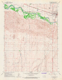
1966 Map of Syracuse West
USGS Topo · Published 1967About this map
The Arkansas River corridor dominates this mid-1960s landscape, flanked by complex irrigation works including the Alamo Ditch and Fort Aubrey Ditch. These canals reflect the critical water management necessary for agriculture on the high plains of Western Kansas. South of the river, the terrain shifts abruptly into the rolling Shifting Sand hills, while to the north, the town of Syracuse serves as the regional hub. The map captures a period of mid-century development, evidenced by the presence of a Drive-in Theater, the Syracuse-Hamilton County Airport, and an active Gas Field. The Atchison Topeka and Santa Fe railroad provides the primary industrial artery, running parallel to the river and connecting local landmarks such as the Fairground and Syracuse Cemetery to the broader rail network of the era.
Find a feature on this map
20 named features on this map. Tap any name to fly to it.
Don’t see what you’re looking for? This feature index may not catch every label — zoom into the map to look around manually.
Map Details
Editions of this 1966 Syracuse West Map
This is the sole edition of this map. No revisions or reprints were ever made.
Other maps of this area

1900 · Syracuse
USGS Topo · 1:125,000

1920 · Syracuse
USGS Topo · 1:125,000

1955 · Dodge City
USGS Topo · 1:250,000

1955 · Scott City
USGS Topo · 1:250,000

1958 · Dodge City
USGS Topo · 1:250,000

1958 · Scott City
USGS Topo · 1:250,000

1959 · Dodge City
USGS Topo · 1:250,000

1966 · Syracuse West SW
USGS Topo · 1:24,000

1966 · Syracuse East SW
USGS Topo · 1:24,000
1966 · Tribune 3 SW
USGS Topo · 1:24,000