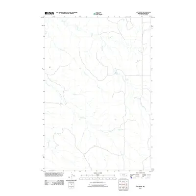
2011 Map of T G Creek
USGS Topo · Published 2011About this map
T G Creek and its seasonal tributaries carve a winding path through this corner of Fallon County, Montana. The landscape is defined by the drainage networks of Pine Creek, Brush Creek, and Timber Creek, which eventually reach O'Fallon Creek. This 2011 survey reflects a sparse, rural environment where water management is critical for land use, as seen at the Askin Dam. The human presence is light, marked primarily by a grid of local corridors like Road 315 and Road 302, which provide access across the high plains. The map's detail on creek bends and topographic contours illustrates the subtle rise and fall of the Eastern Montana terrain, showing how early 21st-century infrastructure follows the natural flow of the watershed.
Find a feature on this map
8 named features on this map. Tap any name to fly to it.
Don’t see what you’re looking for? This feature index may not catch every label — zoom into the map to look around manually.
Map Details
Editions of this 2011 T G Creek Map
This is the sole edition of this map. No revisions or reprints were ever made.
Other maps of this area

1953 · Miles City
USGS Topo · 1:250,000

1957 · Miles City
USGS Topo · 1:250,000

1958 · Miles City
USGS Topo · 1:250,000

1981 · Baker
USGS Topo · 1:100,000

1981 · Harmon Butte
USGS Topo · 1:24,000

1981 · Nelson Butte
USGS Topo · 1:24,000

1981 · Little Pine Creek
USGS Topo · 1:24,000

1981 · Bracket Butte SE
USGS Topo · 1:24,000

1981 · Seven-Up Butte
USGS Topo · 1:24,000
1981 · Plevna
USGS Topo · 1:24,000