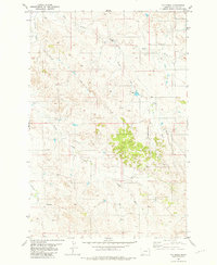
1981 Map of T G Creek
USGS Topo · Published 1981About this map
O'Fallon Creek and its complex network of tributaries define this eastern Montana landscape in Fallon County. The area is characterized by the erosive drainages of T G Creek, Timber Creek, and Brush Creek, illustrating the intricate dissection of the plains by seasonal water flow. Agricultural and ranching infrastructure is evident through the scattered distribution of water sources, including the specifically named Corral Flowing Well, a generic Flowing Well, and various instances of a Spring or Well. This 1981 edition shows the land as it was surveyed in the mid-1970s, documenting a sparsely populated terrain where the primary human footprint consists of unimproved roads and a single Drill Hole, reflecting the search for subsurface resources or water in a semiarid region.
Find a feature on this map
10 named features on this map. Tap any name to fly to it.
Don’t see what you’re looking for? This feature index may not catch every label — zoom into the map to look around manually.
Map Details
Editions of this 1981 T G Creek Map
This is the sole edition of this map. No revisions or reprints were ever made.
Other maps of this area

1953 · Miles City
USGS Topo · 1:250,000

1957 · Miles City
USGS Topo · 1:250,000

1958 · Miles City
USGS Topo · 1:250,000

1981 · Baker
USGS Topo · 1:100,000

1981 · Harmon Butte
USGS Topo · 1:24,000

1981 · Nelson Butte
USGS Topo · 1:24,000

1981 · Little Pine Creek
USGS Topo · 1:24,000

1981 · Bracket Butte SE
USGS Topo · 1:24,000

1981 · Seven-Up Butte
USGS Topo · 1:24,000
1981 · Plevna
USGS Topo · 1:24,000