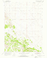
1955 Map of Tabbys Peak SE
USGS Topo · Published 1976About this map
The Cedar Mountains dominate the western portion of this mid-century survey, their slopes dropping sharply toward the desert flats. This area of Tooele County reveals a landscape defined by expansive institutional boundaries, notably the Dugway Proving Ground Military Reservation and a section of an Indian Reservation in the northern reaches. These designations reflect the mid-twentieth-century utilization of the Great Salt Lake Desert for restricted government and tribal purposes.
Find a feature on this map
11 named features on this map. Tap any name to fly to it.
Don’t see what you’re looking for? This feature index may not catch every label — zoom into the map to look around manually.
Map Details
Editions of this 1955 Tabbys Peak SE Map
3 editions found
Other maps of this area

1885 · Tooele Valley
USGS Topo · 1:250,000

1953 · Tooele
USGS Topo · 1:250,000

1954 · Camels Back Ridge NW
USGS Topo · 1:24,000

1955 · Tabbys Peak SE
USGS Topo · 1:24,000

1955 · Tabbys Peak
USGS Topo · 1:24,000

1955 · Camels Back Ridge NE
USGS Topo · 1:24,000

1955 · Davis Knolls
USGS Topo · 1:24,000

1955 · Deseret Peak
USGS Topo · 1:62,500

1955 · Tabbys Peak SW
USGS Topo · 1:24,000

1955 · Tooele
USGS Topo · 1:250,000