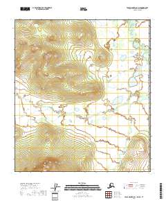
2018 Map of Table Mountain A-1 NE
USGS Topo · Published 2018About this map
The international border of the United States of America defines the eastern edge of this landscape, marking the remote boundary between Alaska and Canada. The terrain is characterized by the winding course of the Old Crow River, which enters the quadrangle in the northeast and creates a complex network of oxbows and wetlands. To the south, Bilwaddy Cr cuts through the topography, draining the western slopes toward the interior. The map illustrates a transitional subarctic environment where high-latitude drainage patterns and seasonal watercourses dominate the land. This 2018 survey provides a clear view of the hydrographic features before they reach the major river systems of the Yukon interior.
Find a feature on this map
7 named features on this map. Tap any name to fly to it.
Don’t see what you’re looking for? This feature index may not catch every label — zoom into the map to look around manually.
Map Details
Editions of this 2018 Table Mountain A-1 NE Map
This is the sole edition of this map. No revisions or reprints were ever made.
Other maps of this area

1951 · Table Mountain
USGS Topo · 1:250,000

1956 · Table Mountain
USGS Topo · 1:250,000

1964 · Table Mountain
USGS Topo · 1:250,000
1972 · Table Mountain B-1
USGS Topo · 1:63,360
1972 · Table Mountain A-1
USGS Topo · 1:63,360
2018 · Table Mountain B-1 SW
USGS Topo · 1:25,000
2018 · Table Mountain B-1 SE
USGS Topo · 1:25,000
2018 · Table Mountain A-1 SW
USGS Topo · 1:25,000
2018 · Table Mountain A-1 NW
USGS Topo · 1:25,000
2018 · Table Mountain A-1 SE
USGS Topo · 1:25,000