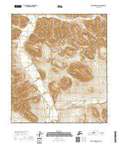
2018 Map of Table Mountain C-3 SE
USGS Topo · Published 2018About this map
High-elevation terrain defines this remote section of the North Slope Borough, where the landscape is primarily characterized by the intersection of several township and range lines including t10s r42e and t11s r41e. The topographic data reveals a complex network of high ridges and deep drainage basins typical of the Brooks Range foothills, visualized through contour intervals of 40 feet. Unlike many lower-lying regions of the state, this area shows a marked absence of named surface water features or established settlements, indicating a territory dominated by natural landforms rather than human infrastructure or transport corridors. The map provides a precise record of the public land survey system grid, which serves as the primary method of orientation in this unpopulated wilderness.
Find a feature on this map
7 named features on this map. Tap any name to fly to it.
Don’t see what you’re looking for? This feature index may not catch every label — zoom into the map to look around manually.
Map Details
Editions of this 2018 Table Mountain C-3 SE Map
This is the sole edition of this map. No revisions or reprints were ever made.
Other maps of this area

1951 · Table Mountain
USGS Topo · 1:250,000

1956 · Table Mountain
USGS Topo · 1:250,000

1964 · Table Mountain
USGS Topo · 1:250,000
1972 · Table Mountain B-3
USGS Topo · 1:63,360
1972 · Table Mountain B-2
USGS Topo · 1:63,360
1983 · Table Mountain C-3
USGS Topo · 1:63,360
1983 · Table Mountain C-2
USGS Topo · 1:63,360
2018 · Table Mountain B-3 NE
USGS Topo · 1:25,000
2018 · Table Mountain C-3 NE
USGS Topo · 1:25,000
2018 · Table Mountain C-3 SW
USGS Topo · 1:25,000