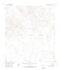
1972 Map of Table Mountain B-2
USGS Topo · Published 1974About this map
The Continental Divide winds through this high-latitude portion of the Arctic National Wildlife Range in the early 1970s. This interior Alaskan terrain is defined by the headwaters and drainage patterns of the Old Crow River and the Coleen River, illustrating a completely roadless landscape where topographical relief dictates all movement. Bear Mountain stands as a prominent high point among the surveyed land lines, which represent locations predetermined by the Bureau of Land Management rather than established ground markers. The intricate paths of Galena Creek and Lois Creek highlight the drainage network in this section of the Yukon-Koyukuk region. This 1972 survey, based on photogrammetric methods from aerial photographs, preserves the pristine state of these protected lands before modern mapping technologies further refined the borderlands between the United States and Canada.
Find a feature on this map
7 named features on this map. Tap any name to fly to it.
Don’t see what you’re looking for? This feature index may not catch every label — zoom into the map to look around manually.
Map Details
Editions of this 1972 Table Mountain B-2 Map
This is the sole edition of this map. No revisions or reprints were ever made.
Other maps of this area

1951 · Table Mountain
USGS Topo · 1:250,000

1956 · Table Mountain
USGS Topo · 1:250,000

1964 · Table Mountain
USGS Topo · 1:250,000
1972 · Table Mountain B-1
USGS Topo · 1:63,360
1972 · Table Mountain B-3
USGS Topo · 1:63,360
1972 · Table Mountain A-2
USGS Topo · 1:63,360
1972 · Table Mountain A-1
USGS Topo · 1:63,360
1972 · Table Mountain A-3
USGS Topo · 1:63,360
1983 · Table Mountain C-1
USGS Topo · 1:63,360
1983 · Table Mountain C-3
USGS Topo · 1:63,360