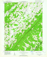
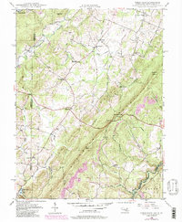
1948 Map of Table Rock
USGS Topo · Published 1962About this map
Little Backbone Mountain dominates this portion of the Appalachian high country along the border between Maryland and West Virginia. Recorded in the late 1940s, the map reveals a rural landscape defined by community centers like the Sunnyside Grange Hall and the Shady Dell Grange Hall, which served as social hubs for the scattered farmsteads. The Western Maryland Railroad snakes through the southern edge near Wilson, following the path of the Potomac River and the small settlement of Silver Lake. Small, local landmarks such as Underwood Church and Beckman Cemetery offer significant points of interest for genealogists tracing family histories in Garrett County. The upper reaches of the Youghiogheny River wind through the northwest, while the high point at Table Rock provides a clear perspective of the surrounding ridges and valley runs.
Find a feature on this map
49 named features on this map. Tap any name to fly to it.
Don’t see what you’re looking for? This feature index may not catch every label — zoom into the map to look around manually.
Map Details
Editions of this 1948 Table Rock Map
5 editions found
Other maps of this area

1886 · St. George
USGS Topo · 1:125,000

1891 · St. George
USGS Topo · 1:125,000

1895 · Piedmont
USGS Topo · 1:125,000

1899 · Oakland
USGS Topo · 1:62,500

1900 · Oakland
USGS Topo · 1:62,500

1907 · Kingwood
USGS Topo · 1:62,500

1908 · Parsons
USGS Topo · 1:62,500

1916 · Davis
USGS Topo · 1:48,000

1918 · Davis
USGS Topo · 1:62,500

1919 · Davis
USGS Topo · 1:62,500