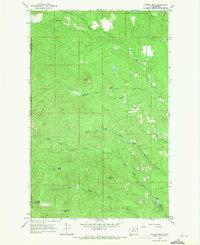
1968 Map of Tacoma Peak
USGS Topo · Published 1971About this map
High elevations and steep drainages dominate this 1968 survey of the Selkirk Mountains along the Stevens Co Pend Oreille Co line. The landscape is defined by its prominent summits, including Calispell Peak and the namesake Tacoma Peak, which anchor a network of alpine ridges. This area served as a critical watershed, with the North Fork Tacoma Creek, South Fork Tacoma Creek, and East Fork Tacoma Creek carving deep valleys that converge as they flow eastward. Historical human activity is marked by a remote site labeled Dirty Shirt and a network of Pack Trails and Jeep Trails, reflecting the era's focus on resource access and lookout maintenance in the high country. To the south, Fourth of July Mountain and the quiet waters of Conger Lake and Conger Pond provide distinct landmarks for those tracing the development of backcountry recreation and land management in Pend Oreille County.
Find a feature on this map
21 named features on this map. Tap any name to fly to it.
Don’t see what you’re looking for? This feature index may not catch every label — zoom into the map to look around manually.
Map Details
Editions of this 1968 Tacoma Peak Map
4 editions found
Other maps of this area

1927 · Chewelah
USGS Topo · 1:125,000

1929 · Colville
USGS Topo · 1:125,000

1930 · Chewelah
USGS Topo · 1:125,000

1933 · Colville
USGS Topo · 1:125,000

1934 · Metaline
USGS Topo · 1:125,000

1936 · Newport
USGS Topo · 1:96,000

1942 · Metaline
USGS Topo · 1:125,000

1942 · Newport
USGS Topo · 1:125,000

1958 · Sandpoint
USGS Topo · 1:250,000

1963 · Sandpoint
USGS Topo · 1:250,000