1949 Map of Taft
USGS Topo · Published 1974About this map
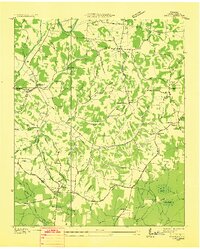
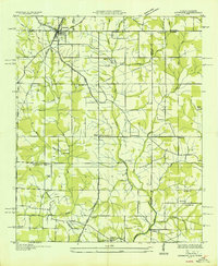
Elk River winds through the northern reaches of this Lincoln County landscape, defining a topography of deep hollows and timbered ridges just before the mid-century. The settlement of Taft serves as a southern anchor, while smaller communities like Molino, Yukon, and Camargo are connected by a network of winding roads and family-named landmarks. The area is dense with genealogical markers, from Smith Chapel and Kirkland Chapel to numerous burial grounds such as Milam Cem and Rawls Cem. Education centers like Marys Grove School and Coldwater School appear alongside low-lying wetlands including Whiteoak Swamp and Locke Swamp. This Tennessee Valley Authority survey captures the transition of the local economy, where the rugged terrain of Sheffield Hollow and Stillhouse Hollow meets the fertile drainage of the Flint River.
Find a feature on this map
62 named features on this map. Tap any name to fly to it.
Don’t see what you’re looking for? This feature index may not catch every label — zoom into the map to look around manually.
Map Details
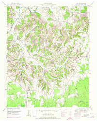
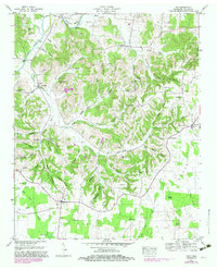
Editions of this 1949 Taft Map
2 editions found
Other maps of this area

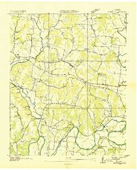
1888 · Huntsville
USGS Topo · 1:125,000

1892 · Huntsville
USGS Topo · 1:125,000
1936 · Taft
USGS Topo · 1:24,000

1936 · Fisk
USGS Topo · 1:24,000
1936 · Boonshill
USGS Topo · 1:24,000
1936 · Ardmore
USGS Topo · 1:24,000

1936 · Lincoln
USGS Topo · 1:24,000

1936 · Toney
USGS Topo · 1:24,000
1936 · Frankewing
USGS Topo · 1:24,000
1936 · Fayetteville
USGS Topo · 1:24,000