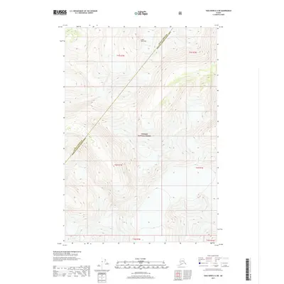
2017 Map of Taku River A-4 SW
USGS Topo · Published 2017About this map
Tongass National Forest dominates this high-altitude landscape where the towering peaks of the Coast Mountains define the local topography. This 2017 survey illuminates the extreme vertical relief of the Alaska panhandle, showing a wilderness area characterized by vast ice fields and steep ridgelines. The map records the jurisdictional boundary between the Juneau Borough Hoonah-Angoon Census Area, a line cutting through some of the most inaccessible terrain in North America. Unlike many lower-elevation maps, the lack of roads or established settlements here emphasizes the area's preservation as a primitive natural environment, where land management is defined by the Public Land Survey System grids such as t44s r74e and t43s r75e. This sheet is an essential reference for understanding the glacial geography and federal land boundaries of the northern Pacific coast.
Find a feature on this map
9 named features on this map. Tap any name to fly to it.
Don’t see what you’re looking for? This feature index may not catch every label — zoom into the map to look around manually.
Map Details
Editions of this 2017 Taku River A-4 SW Map
This is the sole edition of this map. No revisions or reprints were ever made.
Other maps of this area

1948 · Sumdum D-5
USGS Topo · 1:63,360

1951 · Taku River A-4
USGS Topo · 1:63,360

1951 · Taku River A-5
USGS Topo · 1:63,360

1952 · Sumdum
USGS Topo · 1:250,000

1953 · Taku River
USGS Topo · 1:250,000

1955 · Sumdum D-5
USGS Topo · 1:63,360

1960 · Taku River
USGS Topo · 1:250,000

1960 · Sumdum D-4
USGS Topo · 1:63,360

1961 · Sumdum
USGS Topo · 1:250,000
1994 · Sumdum D-5
USGS Topo · 1:63,360