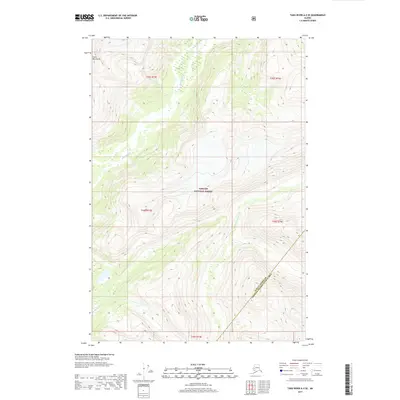
2017 Map of Taku River A-5 SE
USGS Topo · Published 2017About this map
Coast Mountains terrain dominates this remote section of the Tongass National Forest, where steep ridgelines and deep glacial valleys define the landscape of Southeast Alaska. The Whiting River carves a path through the northwestern corner of the quadrangle, serving as the primary drainage for the surrounding peaks. This 2017 survey details the complex topography along the boundary between the Juneau Borough Hoonah-Angoon Census Area, capturing a wilderness devoid of modern infrastructure or permanent settlements. The map provides a precise look at the natural drainage patterns and elevation shifts that characterize this portion of the Alaskan panhandle, offering essential data for understanding the physical geography of the high latitudes.
Find a feature on this map
9 named features on this map. Tap any name to fly to it.
Don’t see what you’re looking for? This feature index may not catch every label — zoom into the map to look around manually.
Map Details
Editions of this 2017 Taku River A-5 SE Map
This is the sole edition of this map. No revisions or reprints were ever made.
Other maps of this area

1948 · Sumdum D-5
USGS Topo · 1:63,360

1951 · Taku River A-4
USGS Topo · 1:63,360

1951 · Taku River A-5
USGS Topo · 1:63,360

1952 · Sumdum
USGS Topo · 1:250,000

1953 · Taku River
USGS Topo · 1:250,000

1955 · Sumdum D-5
USGS Topo · 1:63,360

1960 · Taku River
USGS Topo · 1:250,000

1960 · Sumdum D-4
USGS Topo · 1:63,360

1961 · Sumdum
USGS Topo · 1:250,000
1994 · Sumdum D-5
USGS Topo · 1:63,360