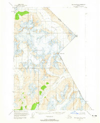
1951 Map of Taku River B-5
USGS Topo · Published 1965About this map
Wright Glacier and Speel Glacier dominate this rugged topographical survey of the international border between Alaska and British Columbia. Mapped in the early 1950s, the terrain is characterized by massive ice fields and steep peaks within the Tongass National Forest. The boundary line is defined by high-altitude landmarks including Mount Ogden, Mt Fremont Morse, and Mt Brundage. Below the glacial reaches, the Speel River flows through the southern portion of the quadrangle, which also captures Speel Lake and the northern drainage of Hidden Creek. This map preserves the remote character of the Boundary Ranges before modern environmental shifts, documenting the precise location of the United States and Canada border through some of the most isolated reaches of the Alaska Panhandle.
Find a feature on this map
11 named features on this map. Tap any name to fly to it.
Don’t see what you’re looking for? This feature index may not catch every label — zoom into the map to look around manually.
Map Details
Editions of this 1951 Taku River B-5 Map
4 editions found
Other maps of this area

1951 · Taku River A-4
USGS Topo · 1:63,360

1951 · Taku River B-6
USGS Topo · 1:63,360

1951 · Taku River A-5
USGS Topo · 1:63,360

1951 · Taku River A-6
USGS Topo · 1:63,360

1951 · Taku River B-5
USGS Topo · 1:63,360

1953 · Taku River
USGS Topo · 1:250,000
1960 · Taku River C-5
USGS Topo · 1:63,360

1960 · Taku River C-6
USGS Topo · 1:63,360

1960 · Taku River
USGS Topo · 1:250,000

1994 · Taku River B-6
USGS Topo · 1:63,360