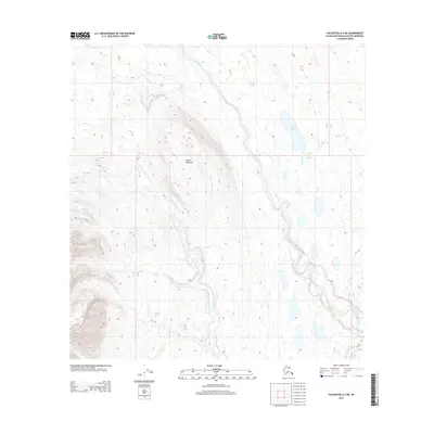
2013 Map of Talkeetna A-3 NE
USGS Topo · Published 2013About this map
Willow Mountain dominates the western topography of this Alaskan landscape, rising above a network of glacial valleys and wetlands in the Matanuska-Susitna Borough. The drainage of Lake Creek carves a significant path through the center of the sheet, served by several smaller tributaries including Yenlo Cr and Shovel Cr. The area is characterized by high-latitude water features like Shovel Lake, showing a terrain largely defined by its natural hydrology rather than industrial or residential development. This 2013 survey provides a clear look at the topographic contours and the intricate mesh of seasonal streams and ponds that shape this wilderness area north of the Susitna River valley.
Find a feature on this map
8 named features on this map. Tap any name to fly to it.
Don’t see what you’re looking for? This feature index may not catch every label — zoom into the map to look around manually.
Map Details
Editions of this 2013 Talkeetna A-3 NE Map
This is the sole edition of this map. No revisions or reprints were ever made.
Other maps of this area

1950 · Talkeetna
USGS Topo · 1:250,000

1951 · Talkeetna
USGS Topo · 1:250,000

1954 · Talkeetna A-3
USGS Topo · 1:63,360

1954 · Talkeetna A-2
USGS Topo · 1:63,360

1954 · Talkeetna B-3
USGS Topo · 1:63,360

1954 · Talkeetna B-2
USGS Topo · 1:63,360

1958 · Talkeetna
USGS Topo · 1:250,000

1965 · Talkeetna
USGS Topo · 1:250,000
1994 · Talkeetna B-2
USGS Topo · 1:63,360
1994 · Talkeetna A-2
USGS Topo · 1:63,360