
1954 Map of Talkeetna A-2
USGS Topo · Published 1961About this map
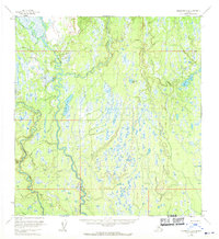
The Kahiltna River snakes through this Alaskan landscape, defining a complex network of waterways and wetlands recorded in the early 1950s. The terrain is characterized by a high density of small lakes and marshes, with larger bodies of water such as Shulin Lake and Amber Lake serving as landmarks in an otherwise unsurveyed wilderness. Human presence is sparse, marked primarily by isolated Cabins near the southern shore of Shulin Lake and another Cabin structure to the north. These small outposts suggest the area served as a base for seasonal trapping or early exploration. Glacial drainage patterns are evident in the courses of Peters Creek, Treasure Creek, and Kroto Creek, which feed into the primary river system. This survey represents the region before modern infrastructure, when land lines remained predetermined by the Bureau of Land Management rather than marked on the ground.
Find a feature on this map
12 named features on this map. Tap any name to fly to it.
Don’t see what you’re looking for? This feature index may not catch every label — zoom into the map to look around manually.
Map Details
Editions of this 1954 Talkeetna A-2 Map
3 editions found
Other maps of this area

1949 · Tyonek
USGS Topo · 1:250,000

1950 · Talkeetna
USGS Topo · 1:250,000

1951 · Talkeetna
USGS Topo · 1:250,000

1951 · Talkeetna B-1
USGS Topo · 1:63,360

1951 · Tyonek
USGS Topo · 1:250,000

1952 · Talkeetna A-1
USGS Topo · 1:63,360

1954 · Tyonek D-2
USGS Topo · 1:63,360

1954 · Tyonek D-3
USGS Topo · 1:63,360

1954 · Talkeetna A-3
USGS Topo · 1:63,360

1954 · Talkeetna B-3
USGS Topo · 1:63,360