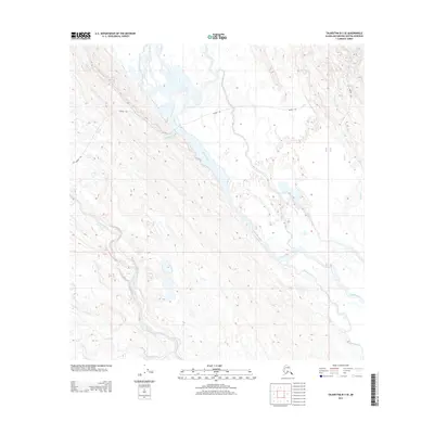
2013 Map of Talkeetna B-3 SE
USGS Topo · Published 2013About this map
Kahiltna River dominates this landscape, its braided channels and vast gravel bars shifting through the center of the terrain. This environment, characterized by low-lying wetlands and complex water systems, is defined by the seasonal movement of water and ice. A critical historical and practical transport route, the Winter Trl, crosses the river and navigates the surrounding marshes, indicating how the region was traversed when the ground was frozen. Tributaries like Lake Creek and Treasure Creek feed into the larger river system, carving through the topographic contours that rise away from the central valley. The absence of permanent structures or modern roads highlights the remote nature of this portion of the Matanuska-Susitna Borough, where seasonal trails and natural waterways remain the primary means of navigation.
Find a feature on this map
11 named features on this map. Tap any name to fly to it.
Don’t see what you’re looking for? This feature index may not catch every label — zoom into the map to look around manually.
Map Details
Editions of this 2013 Talkeetna B-3 SE Map
This is the sole edition of this map. No revisions or reprints were ever made.
Other maps of this area

1950 · Talkeetna
USGS Topo · 1:250,000

1951 · Talkeetna
USGS Topo · 1:250,000

1954 · Talkeetna A-3
USGS Topo · 1:63,360

1954 · Talkeetna A-2
USGS Topo · 1:63,360

1954 · Talkeetna B-3
USGS Topo · 1:63,360

1954 · Talkeetna B-2
USGS Topo · 1:63,360

1958 · Talkeetna
USGS Topo · 1:250,000

1965 · Talkeetna
USGS Topo · 1:250,000
1994 · Talkeetna B-2
USGS Topo · 1:63,360
1994 · Talkeetna A-2
USGS Topo · 1:63,360