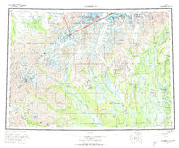
1958 Map of Talkeetna
USGS Topo · Published 1973About this map
Mount McKinley National Park and the massive peaks of the Alaska Range dominate this mid-century landscape, where the high-altitude terrain is defined by the massive Kahiltna Glacier and Ruth Glacier. In the lowlands, the Alaska Railroad follows the Susitna River, connecting small settlements like Talkeetna and Chase. This era shows a transition in northern travel, documenting the historic Old Iditarod Trail and a Winter Trail as they navigate the river valleys and mountain passes. Remote outposts such as Petersville and Collinsville serve as gateways to the mining and hunting grounds of the Yenlo Hills. The complex drainage system of the Yentna River and its tributaries, including the Kichatna River, reveals the braided waterways that dictated movement through the territory before modern road networks were established.
Find a feature on this map
109 named features on this map. Tap any name to fly to it.
Don’t see what you’re looking for? This feature index may not catch every label — zoom into the map to look around manually.
Map Details
Editions of this 1958 Talkeetna Map
5 editions found

Other maps of this area

1949 · Tyonek
USGS Topo · 1:250,000

1949 · McGrath
USGS Topo · 1:250,000

1949 · Talkeetna Mountains D-6
USGS Topo · 1:63,360

1949 · Talkeetna Mountains B-6
USGS Topo · 1:63,360

1949 · Talkeetna Mountains C-6
USGS Topo · 1:63,360

1949 · Anchorage D-8
USGS Topo · 1:63,360

1949 · Healy A-6
USGS Topo · 1:63,360

1950 · Medfra
USGS Topo · 1:250,000

1950 · McGrath
USGS Topo · 1:250,000

1950 · Talkeetna Mountains
USGS Topo · 1:250,000