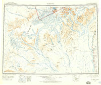
1950 Map of Talkeetna
USGS Topo · Published 1960About this map
The Alaska Range dominates this mid-century survey, with massive ice features like the Kahiltna Glacier and Chedotlothna Glacier carving through the granite peaks of Mount Mc Kinley National Park. Settlement is sparse and focused along the river corridors, where the Alaska Railroad parallels the Susitna River, connecting small outposts like Talkeetna and Sunshine. In the interior, the map documents the infrastructure of Alaskan aviation and mining, including the Mills Creek Airstrip, the Aerial Tram, and the now-abandoned settlement at Youngstown. To the west, remote lodges such as Chelatna Lodge and Puntilla Lake Lodge provide rare points of habitation in the shadow of peaks like Mt Russell and Mt Dall. This edition captures a transition in the backcountry, marking sites like Sunflower as abandoned while maintaining the active trails and mining camps of the Peters Hills.
Find a feature on this map
110 named features on this map. Tap any name to fly to it.
Don’t see what you’re looking for? This feature index may not catch every label — zoom into the map to look around manually.
Map Details
Editions of this 1950 Talkeetna Map
2 editions found

Other maps of this area

1949 · Tyonek
USGS Topo · 1:250,000

1949 · McGrath
USGS Topo · 1:250,000

1949 · Talkeetna Mountains D-6
USGS Topo · 1:63,360

1949 · Talkeetna Mountains B-6
USGS Topo · 1:63,360

1949 · Talkeetna Mountains C-6
USGS Topo · 1:63,360

1949 · Anchorage D-8
USGS Topo · 1:63,360

1949 · Healy A-6
USGS Topo · 1:63,360

1950 · Medfra
USGS Topo · 1:250,000

1950 · McGrath
USGS Topo · 1:250,000

1950 · Talkeetna Mountains
USGS Topo · 1:250,000