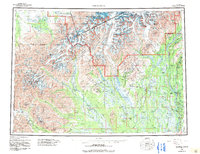
1958 Map of Talkeetna
USGS Topo · Published 1992About this map
Talkeetna serves as the central hub of this mid-century interior landscape, situated at the confluence of the Susitna, Chulitna, and Talkeetna River systems. The corridor of the Alaska Railroad and the emerging Parks Highway dictate the pattern of growth along the eastern edge, connecting settlements like Chase, Curry, and Sunshine. To the west, the landscape transitions into the towering heights of the Alaska Range and the protected reaches of Denali National Park and Preserve, where peaks such as Mt Hunter and Mt Foraker dominate the horizon. Historical transit routes are visible through the interior, including the Old Iditarod Trail and various stretches of Winter Trail that once linked mining and trapping outposts. Remote settlements such as Petersville and Collinsville are documented near the Kahiltna River, illustrating the era's scattered mining and aviation-dependent infrastructure before modern road networks fully penetrated the backcountry.
Find a feature on this map
186 named features on this map. Tap any name to fly to it.
Don’t see what you’re looking for? This feature index may not catch every label — zoom into the map to look around manually.
Map Details
Editions of this 1958 Talkeetna Map
5 editions found

Other maps of this area

1949 · Tyonek
USGS Topo · 1:250,000

1949 · McGrath
USGS Topo · 1:250,000

1949 · Talkeetna Mountains D-6
USGS Topo · 1:63,360

1949 · Talkeetna Mountains B-6
USGS Topo · 1:63,360

1949 · Talkeetna Mountains C-6
USGS Topo · 1:63,360

1949 · Anchorage D-8
USGS Topo · 1:63,360

1949 · Healy A-6
USGS Topo · 1:63,360

1950 · Medfra
USGS Topo · 1:250,000

1950 · McGrath
USGS Topo · 1:250,000

1950 · Talkeetna Mountains
USGS Topo · 1:250,000