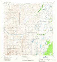
1949 Map of Talkeetna Mountains A-1
USGS Topo · Published 1966About this map
The confluence of the Little Nelchina River and the Nelchina River forms a central geographical point in this interior Alaskan landscape. This 1949 survey, which includes minor revisions from 1965, documents a vast network of watercourses within the Matanuska Susitna Borough, including Tyone Creek and Crooked Creek. A notable human element is the site of Nelchina (Abandoned), indicating an early 20th-century settlement or trail stop that had already been vacated by the time of the field annotation.
Find a feature on this map
28 named features on this map. Tap any name to fly to it.
Don’t see what you’re looking for? This feature index may not catch every label — zoom into the map to look around manually.
Map Details
Editions of this 1949 Talkeetna Mountains A-1 Map
4 editions found
Other maps of this area

1948 · Anchorage D-2
USGS Topo · 1:63,360

1948 · Anchorage D-1
USGS Topo · 1:63,360

1949 · Talkeetna Mountains A-1
USGS Topo · 1:63,360

1949 · Gulkana A-6
USGS Topo · 1:63,360

1949 · Valdez D-8
USGS Topo · 1:63,360

1950 · Talkeetna Mountains
USGS Topo · 1:250,000

1950 · Gulkana B-6
USGS Topo · 1:63,360

1951 · Gulkana
USGS Topo · 1:250,000

1951 · Anchorage
USGS Topo · 1:250,000

1951 · Anchorage D-1
USGS Topo · 1:63,360