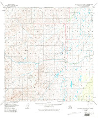
1949 Map of Talkeetna Mountains A-1
USGS Topo · Published 1982About this map
Little Nelchina River and its confluence with the Nelchina River define this stretch of the Matanuska-Susitna region during the late 1940s. The landscape is characterized by a network of drainage systems, including Tyone Creek and Crooked Creek, which flow through the high country surrounding the Horn Mountains and White Hill. Evidence of early resource extraction is visible at the Placer Mine near Albert Creek, a site of interest for those tracking mining history in the Alaskan interior. Transportation is limited to a few scattered Trails and the presence of the Nelchina (Siding), suggesting a period when infrastructure was minimal and tied to remote rail or river access points. The eastern portion of the survey is marked by the Seward Meridian, providing a primary geographic reference for the surrounding unsurveyed land.
Find a feature on this map
35 named features on this map. Tap any name to fly to it.
Don’t see what you’re looking for? This feature index may not catch every label — zoom into the map to look around manually.
Map Details
Editions of this 1949 Talkeetna Mountains A-1 Map
4 editions found
Other maps of this area

1948 · Anchorage D-2
USGS Topo · 1:63,360

1948 · Anchorage D-1
USGS Topo · 1:63,360

1949 · Talkeetna Mountains A-1
USGS Topo · 1:63,360

1949 · Gulkana A-6
USGS Topo · 1:63,360

1949 · Valdez D-8
USGS Topo · 1:63,360

1950 · Talkeetna Mountains
USGS Topo · 1:250,000

1950 · Gulkana B-6
USGS Topo · 1:63,360

1951 · Gulkana
USGS Topo · 1:250,000

1951 · Anchorage
USGS Topo · 1:250,000

1951 · Anchorage D-1
USGS Topo · 1:63,360