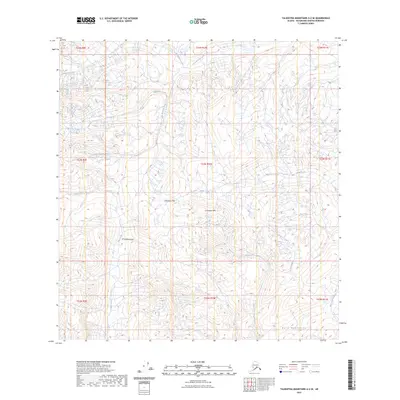
2023 Map of Talkeetna Mountains A-2 SE
USGS Topo · Published 2023About this map
The Horn Mountains define the southern reaches of this high-elevation landscape in the Talkeetna Mountains. The terrain is structured by a network of drainage systems, including the Little Nelchina River and its various tributaries like Billy Creek and Bubb Creek. Geologically significant features such as the Limestone Hills, Limestone Gap, and Limestone Gulch suggest a distinct carbonate-based topography rare for the broader region. The lack of roads or established settlements emphasizes the remote nature of this portion of the Matanuska-Susitna Borough, where the intricate contour lines reveal sharp elevation changes and deep valleys carved by seasonal waterways like Cadoceras Creek and Flume Creek. This detailed elevation data provides a clear record of the glacial and hydrological forces shaping this interior Alaskan wilderness.
Find a feature on this map
21 named features on this map. Tap any name to fly to it.
Don’t see what you’re looking for? This feature index may not catch every label — zoom into the map to look around manually.
Map Details
Editions of this 2023 Talkeetna Mountains A-2 SE Map
This is the sole edition of this map. No revisions or reprints were ever made.
Other maps of this area

1948 · Anchorage D-3
USGS Topo · 1:63,360

1948 · Anchorage D-2
USGS Topo · 1:63,360

1949 · Talkeetna Mountains A-1
USGS Topo · 1:63,360

1950 · Talkeetna Mountains
USGS Topo · 1:250,000

1951 · Anchorage
USGS Topo · 1:250,000

1951 · Talkeetna Mountains A-2
USGS Topo · 1:63,360

1952 · Anchorage D-2
USGS Topo · 1:63,360

1952 · Anchorage D-3
USGS Topo · 1:63,360
1952 · Talkeetna Mountains A-1
USGS Topo · 1:63,360
1952 · Talkeetna Mountains A-2
USGS Topo · 1:63,360