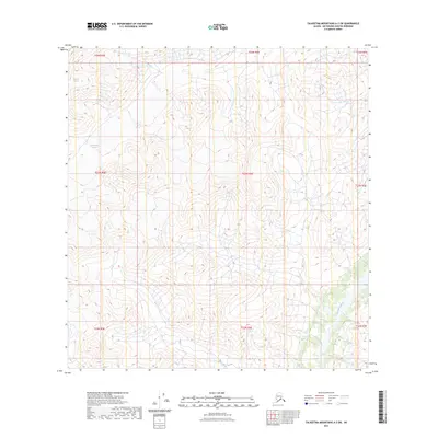
2023 Map of Talkeetna Mountains A-3 SW
USGS Topo · Published 2023About this map
Talkeetna Glacier and Chickaloon Glacier dominate the high-elevation landscape of this Matanuska-Susitna region, where glacial ice and meltwater dictate the drainage patterns of the upper Chickaloon River valley. The map documents a strictly wilderness terrain, devoid of permanent settlements or named structures, focusing instead on the complex hydrography and elevation gradients of the Talkeetna Mountains. In the southern portion of the sheet, the headwaters of Moss Creek begin their descent through the steep valleys. This survey provides a precise look at glacial extents as of the early 21st century, offering critical data for those studying the movement of ice fields and the natural evolution of Alaskan water systems in the t24n r5e through t22n r7e townships.
Find a feature on this map
13 named features on this map. Tap any name to fly to it.
Don’t see what you’re looking for? This feature index may not catch every label — zoom into the map to look around manually.
Map Details
Editions of this 2023 Talkeetna Mountains A-3 SW Map
This is the sole edition of this map. No revisions or reprints were ever made.
Other maps of this area

1948 · Anchorage D-4
USGS Topo · 1:63,360

1949 · Anchorage D-5
USGS Topo · 1:63,360

1949 · Talkeetna Mountains A-4
USGS Topo · 1:63,360

1950 · Talkeetna Mountains
USGS Topo · 1:250,000

1951 · Anchorage
USGS Topo · 1:250,000

1951 · Talkeetna Mountains A-3
USGS Topo · 1:63,360

1952 · Anchorage D-5
USGS Topo · 1:63,360

1952 · Anchorage D-4
USGS Topo · 1:63,360
1952 · Talkeetna Mountains A-3
USGS Topo · 1:63,360
1954 · Talkeetna Mountains A-4
USGS Topo · 1:63,360