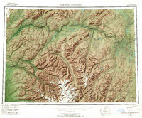
1966 Map of Talkeetna Mountains
USGS Topo · Published 1966About this map
The Alaska Railroad corridor defines the western edge of this mid-century landscape, threading through the narrow river valleys that separate the massive Talkeetna Mountains from the surrounding highlands. This 1966 revision illustrates a series of small railroad-aligned settlements including Hurricane, Gold Creek, Sherman, and Curry, which served as vital transport nodes before the extensive development of the state's modern road network.
Find a feature on this map
115 named features on this map. Tap any name to fly to it.
Don’t see what you’re looking for? This feature index may not catch every label — zoom into the map to look around manually.
Map Details
Editions of this 1966 Talkeetna Mountains Map
This is the sole edition of this map. No revisions or reprints were ever made.
Other maps of this area

1948 · Anchorage D-3
USGS Topo · 1:63,360

1948 · Anchorage D-2
USGS Topo · 1:63,360

1948 · Anchorage D-4
USGS Topo · 1:63,360

1948 · Anchorage D-1
USGS Topo · 1:63,360

1949 · Tyonek
USGS Topo · 1:250,000

1949 · Talkeetna Mountains D-6
USGS Topo · 1:63,360

1949 · Anchorage D-5
USGS Topo · 1:63,360

1949 · Anchorage D-7
USGS Topo · 1:63,360

1949 · Talkeetna Mountains B-6
USGS Topo · 1:63,360

1949 · Talkeetna Mountains A-1
USGS Topo · 1:63,360