
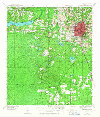
1940 Map of Tallahassee
USGS Topo · Published 1958About this map
The growing state capital of Tallahassee anchors this pre-war landscape, where the concentrated urban grid of the downtown area transitions into the dense woodlands of the Apalachicola National Forest. This era shows the early footprints of major institutions, including State College and the Florida Agricultural and Mechanical College, alongside the Municipal Airport. To the west, the Ochlockonee River feeds into Lake Talquin, a significant water feature that defines the western boundary of the county.
Find a feature on this map
57 named features on this map. Tap any name to fly to it.
Don’t see what you’re looking for? This feature index may not catch every label — zoom into the map to look around manually.
Map Details
Editions of this 1940 Tallahassee Map
2 editions found
Other maps of this area

1940 · Arran
USGS Topo · 1:62,500

1942 · Tallahassee
USGS Topo · 1:62,500

1943 · Arran
USGS Topo · 1:62,500

1943 · Tallahassee
USGS Topo · 1:62,500

1943 · Lake Talquin
USGS Topo · 1:62,500

1945 · Bradwell Bay
USGS Topo · 1:31,680

1954 · Lafayette
USGS Topo · 1:24,000

1954 · Woodville
USGS Topo · 1:24,000

1954 · St. Marks
USGS Topo · 1:24,000

1954 · Tallahassee
USGS Topo · 1:250,000