
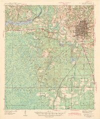
1943 Map of Tallahassee
USGS Topo · Published 1943About this map
Tallahassee sits at a geographic crossroads in the early 1940s, serving as a hub where the Seaboard Railroad and Meridian Road converge. The state capital's footprint includes the Florida Agricultural and Mechanical College and the Municipal Airport, set against a landscape of deep-rooted rural communities. To the west, the recently created Lake Talquin and the sprawling Apalachicola National Forest dominate the terrain, defining a transition from urban development to timber and conservation lands. The survey reveals a dense network of country schools and churches, such as Macon Sch and Vaughan Chapel, which anchored small settlements like Hilliardville and Woodville before post-war expansion. This mapping also traces the important historical boundaries of the Purchase Line and Base Line, essential markers of the region's early land division and surveying heritage.
Find a feature on this map
57 named features on this map. Tap any name to fly to it.
Don’t see what you’re looking for? This feature index may not catch every label — zoom into the map to look around manually.
Map Details
Editions of this 1943 Tallahassee Map
2 editions found
Other maps of this area

1940 · Tallahassee
USGS Topo · 1:62,500

1940 · Arran
USGS Topo · 1:62,500

1942 · Tallahassee
USGS Topo · 1:62,500

1943 · Arran
USGS Topo · 1:62,500

1943 · Lake Talquin
USGS Topo · 1:62,500

1945 · Bradwell Bay
USGS Topo · 1:31,680

1954 · Lafayette
USGS Topo · 1:24,000

1954 · Woodville
USGS Topo · 1:24,000

1954 · St. Marks
USGS Topo · 1:24,000

1954 · Tallahassee
USGS Topo · 1:250,000