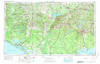
1954 Map of Tallahassee
USGS Topo · Published 1973About this map
Tallahassee stands as the inland hub of this mid-century landscape, a point where the Seaboard Air Line and Atlantic Coast Line railroads converge amidst a network of lakes and river systems. To the west, the massive reservoir of Lake Seminole dominates the junction of the Chattahoochee and Flint rivers, feeding the Apalachicola River as it cuts south toward the coast. The mapping of the 1950s and 1960s captures a distinct era of regional defense and conservation, evidenced by the expansive Tyndall Air Force Base near Panama City and the coastal stretches of the St Marks National Wildlife Refuge. From the river port of Bainbridge to the historic Fort San Marcos at the confluence of the St Marks River and Wakulla River, the map illustrates a transition from agricultural river valleys to the dense pine woods of the Apalachicola National Forest.
Find a feature on this map
84 named features on this map. Tap any name to fly to it.
Don’t see what you’re looking for? This feature index may not catch every label — zoom into the map to look around manually.
Map Details
Editions of this 1954 Tallahassee Map
4 editions found

Other maps of this area

1935 · De Funiak Springs
USGS Topo · 1:48,000

1936 · Point Washington
USGS Topo · 1:48,000

1938 · De Funiak Springs
USGS Topo · 1:62,500

1939 · Point Washington
USGS Topo · 1:62,500

1940 · Tallahassee
USGS Topo · 1:62,500

1940 · Arran
USGS Topo · 1:62,500

1942 · Enterprise
USGS Topo · 1:125,000

1942 · Tallahassee
USGS Topo · 1:62,500

1943 · Arran
USGS Topo · 1:62,500

1943 · Beacon Beach
USGS Topo · 1:31,680