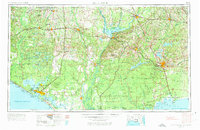
1954 Map of Tallahassee
USGS Topo · Published 1973About this map
Tallahassee stands as the inland focal point of this regional study, which bridges the rolling red hills of the Florida Panhandle and Southwest Georgia with the coastal lowlands of the Gulf. The mid-century landscape is defined by massive hydraulic and infrastructure projects, most notably the expanse of Lake Seminole at the confluence of the Chattahoochee River and Flint River. This reservoir, along with the nearby Lake Talquin, illustrates the era's focus on water management and power generation.
Find a feature on this map
50 named features on this map. Tap any name to fly to it.
Don’t see what you’re looking for? This feature index may not catch every label — zoom into the map to look around manually.
Map Details
Editions of this 1954 Tallahassee Map
4 editions found

Other maps of this area

1935 · De Funiak Springs
USGS Topo · 1:48,000

1936 · Point Washington
USGS Topo · 1:48,000

1938 · De Funiak Springs
USGS Topo · 1:62,500

1939 · Point Washington
USGS Topo · 1:62,500

1940 · Tallahassee
USGS Topo · 1:62,500

1940 · Arran
USGS Topo · 1:62,500

1942 · Enterprise
USGS Topo · 1:125,000

1942 · Tallahassee
USGS Topo · 1:62,500

1943 · Arran
USGS Topo · 1:62,500

1943 · Beacon Beach
USGS Topo · 1:31,680