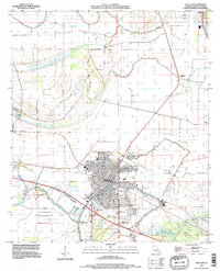
1994 Map of Tallulah
USGS Topo · Published 1997About this map
Tallulah serves as the focal point of this Madison Parish landscape, showing a dense street grid organized around a central corridor and the Tallulah Corporate Boundary. The area is defined by a complex network of waterways, where the meandering Brushy Bayou and Panola Bayou wind past several local landmarks. Researchers will find significant genealogical interest in the clustered cemeteries and churches situated near the town center and its outskirts, including Oakwood Cem, Silver Cross Cem, and Morning Crest Ch.
Find a feature on this map
35 named features on this map. Tap any name to fly to it.
Don’t see what you’re looking for? This feature index may not catch every label — zoom into the map to look around manually.
Map Details
Editions of this 1994 Tallulah Map
This is the sole edition of this map. No revisions or reprints were ever made.
Other maps of this area

1909 · Millikens Bend
USGS Topo · 1:24,000

1909 · Tallulah
USGS Topo · 1:24,000

1909 · Mound
USGS Topo · 1:24,000

1910 · Mound
USGS Topo · 1:31,680

1935 · Waverly
USGS Topo · 1:62,500

1939 · Talla Bena
USGS Topo · 1:62,500

1939 · Alsatia
USGS Topo · 1:62,500

1955 · Jackson
USGS Topo · 1:250,000

1959 · Mitchiner
USGS Topo · 1:62,500

1961 · Jackson
USGS Topo · 1:250,000