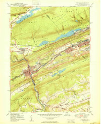
1950 Map of Tamaqua
USGS Topo · Published 1950About this map
Tamaqua and its neighboring anthracite coal towns sit at the center of this 1950 industrial landscape, where the geography is defined as much by mining as by the mountain ridges. The terrain is deeply marked by extensive Strip Mine operations, Tailings piles, and numerous Mine shafts scattered across Nesquehoning Mountain and Sharp Mountain. This era of extraction is supported by a complex rail network including the Reading and Central RR of Pennsylvania, which converge at major hubs like Arlington Yards. Beyond the heavy industry of Coaldale and Lansford, the map shows local life through rural landmarks such as the Wash Creek Sch and the Odd Fellows Cem. The Little Schuylkill River carves a path through the valley, flanked by reservoirs like the Still Creek Reservoir that served the growing mid-century population.
Find a feature on this map
58 named features on this map. Tap any name to fly to it.
Don’t see what you’re looking for? This feature index may not catch every label — zoom into the map to look around manually.
Map Details
Editions of this 1950 Tamaqua Map
2 editions found
Other maps of this area

1889 · Hazleton
USGS Topo · 1:62,500

1889 · Pottsville
USGS Topo · 1:62,500

1891 · Hazleton
USGS Topo · 1:62,500

1891 · Pottsville
USGS Topo · 1:62,500

1892 · Mahanoy
USGS Topo · 1:62,500

1893 · Hazleton
USGS Topo · 1:62,500

1893 · Mahanoy
USGS Topo · 1:62,500

1909 · Hamburg
USGS Topo · 1:62,500

1911 · Hamburg
USGS Topo · 1:62,500

1944 · Orwigsburg
USGS Topo · 1:24,000