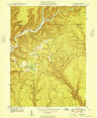
1948 Map of Tamarack
USGS Topo · Published 1948About this map
Kettle Creek carves a deep valley through this corner of the Pennsylvania Wilds, serving as a central drainage for the steep ridges of the Potter Co Clinton Co border. In the late 1940s, the small settlement of Tamarack sits atop a high plateau near the headwaters of Paddy Run and Drury Run, notable for its unique Tamarack Swamp and the nearby Tamarack Lookout Tower used for forest fire detection. To the north, the village of Cross Fork marks a key junction where the stream of the same name meets the main creek valley.
Find a feature on this map
25 named features on this map. Tap any name to fly to it.
Don’t see what you’re looking for? This feature index may not catch every label — zoom into the map to look around manually.
Map Details
Editions of this 1948 Tamarack Map
2 editions found
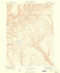
Other maps of this area

1943 · Hyner
USGS Topo · 1:62,500

1946 · Young Womans Creek
USGS Topo · 1:24,000

1946 · Renovo East
USGS Topo · 1:62,500

1946 · Renovo West
USGS Topo · 1:62,500

1946 · Hammersley Fork
USGS Topo · 1:24,000

1946 · Keating
USGS Topo · 1:24,000

1946 · Tamarack
USGS Topo · 1:24,000

1946 · Renovo East
USGS Topo · 1:24,000

1946 · Renovo West
USGS Topo · 1:24,000

1947 · Conrad
USGS Topo · 1:62,500
Featured Places
- Leidy Township, PA
- Wharton Township, PA
- Tamarack, Leidy Township
- Cross Fork, Stewardson Township
- Stewardson Township, PA