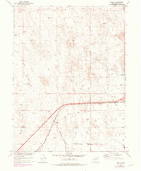
1950 Map of Tampa
USGS Topo · Published 1979About this map
Tampa stands as a primary focal point in this 1950s study of the Weld County plains, situated where the Burlington Northern railroad cuts a diagonal path across the arid landscape. The map reflects a region defined by agricultural persistence and water management, evidenced by the numerous Windmill symbols and the presence of a Well in the eastern sectors. Natural drainage is limited to ephemeral features like Ennis Draw and the wandering course of Lost Creek, which dominates the eastern half of the quadrangle. A sparse settlement pattern is visible, with the Lutz Ranch marking the northwestern reaches. This survey, later updated with purple revisions in the 1970s, captures the evolution of infrastructure in the Missouri River Basin, including the addition of a significant Pipeline corridor crossing through the southern sections.
Find a feature on this map
11 named features on this map. Tap any name to fly to it.
Don’t see what you’re looking for? This feature index may not catch every label — zoom into the map to look around manually.
Map Details
Editions of this 1950 Tampa Map
4 editions found
Other maps of this area

1902 · Greeley
USGS Topo · 1:125,000

1950 · South Roggen
USGS Topo · 1:24,000

1950 · Tampa
USGS Topo · 1:24,000

1950 · Keenesburg
USGS Topo · 1:24,000

1950 · Prospect Valley
USGS Topo · 1:24,000

1950 · Klug Ranch
USGS Topo · 1:24,000

1950 · Valley View School
USGS Topo · 1:24,000

1950 · Hardin
USGS Topo · 1:24,000

1951 · Keenesburg
USGS Topo · 1:24,000

1951 · Prospect Valley
USGS Topo · 1:24,000