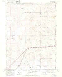
1950 Map of Tampa
USGS Topo · Published 1979About this map
Tampa serves as a central point of reference in this landscape of the High Plains, where the Burlington Northern railroad corridor dictates the regional orientation. The terrain is defined by dry drainage systems such as Ennis Draw and Lost Creek, which cut through the open country. This 1950s survey, updated in the late 1970s, reveals a persistent agricultural and ranching infrastructure, most notably at Lutz Ranch. The abundance of marked Windmills and Wells underscore the vital importance of groundwater management in this arid Weld County environment. A significant Pipeline also traverses the southern sections, indicating the area's role in energy transport during the mid-to-late 20th century.
Find a feature on this map
10 named features on this map. Tap any name to fly to it.
Don’t see what you’re looking for? This feature index may not catch every label — zoom into the map to look around manually.
Map Details
Editions of this 1950 Tampa Map
4 editions found
Other maps of this area

1902 · Greeley
USGS Topo · 1:125,000

1950 · South Roggen
USGS Topo · 1:24,000

1950 · Tampa
USGS Topo · 1:24,000

1950 · Keenesburg
USGS Topo · 1:24,000

1950 · Prospect Valley
USGS Topo · 1:24,000

1950 · Klug Ranch
USGS Topo · 1:24,000

1950 · Valley View School
USGS Topo · 1:24,000

1950 · Hardin
USGS Topo · 1:24,000

1951 · Keenesburg
USGS Topo · 1:24,000

1951 · Prospect Valley
USGS Topo · 1:24,000