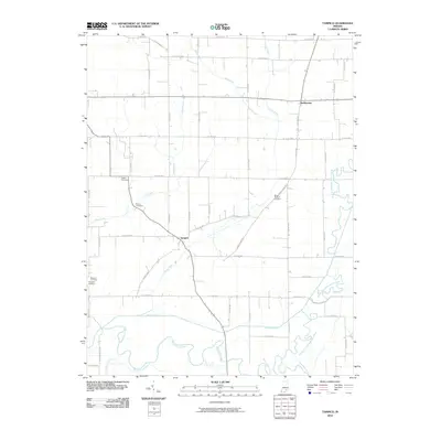
2010 Map of Tampico
USGS Topo · Published 2010About this map
The low-lying bottomlands of the Muscatatuck River and the Vernon Fork Muscatatuck River define the southern and eastern reaches of this Jackson County landscape. The area is characterized by an extensive network of managed waterways, such as the Breitfield-Ditch and Smart Ditch, designed to drain the flat terrain for agricultural use. Settlements like Tampico and Dudleytown serve as local hubs, connected by a grid of rural roads and the diagonal path of the Dudleytown Spr. Local history is preserved in numerous family and community burial grounds, including Lubker Cemetery, Rucker Cemetery, and the Waskom Cemetery Sturgeon Cemetery. The map captures the meeting of several significant creeks, including Grassy Fork, Horse Lick, and Pond Creek, as they converge toward the larger river systems that dominate the southern border.
Find a feature on this map
31 named features on this map. Tap any name to fly to it.
Don’t see what you’re looking for? This feature index may not catch every label — zoom into the map to look around manually.
Map Details
Editions of this 2010 Tampico Map
This is the sole edition of this map. No revisions or reprints were ever made.
Other maps of this area

1947 · Scottsburg
USGS Topo · 1:24,000

1953 · Kossuth
USGS Topo · 1:24,000

1956 · Vincennes
USGS Topo · 1:250,000

1956 · Louisville
USGS Topo · 1:250,000

1957 · Vincennes
USGS Topo · 1:250,000

1958 · Vincennes
USGS Topo · 1:250,000

1958 · Little York
USGS Topo · 1:24,000

1958 · Brownstown
USGS Topo · 1:24,000

1958 · Seymour
USGS Topo · 1:24,000
1959 · Vallonia
USGS Topo · 1:24,000