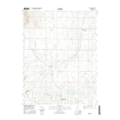
2016 Map of Tampico
USGS Topo · Published 2016About this map
Tampico and Dudleytown anchor this section of southern Jackson County, situated amidst a landscape defined by the intricate drainage of the Muscatatuck River system. The low-lying southern region is dominated by the primary river channel and its wide floodplain, where man-made improvements like Smart Ditch and Connie Thomas Ditch reflect long-standing efforts to manage the wet bottomlands. Further north, the terrain becomes more structured with several smaller watercourses including Grassy Fork, Horse Lick, and Pond Cr. Local history is preserved in numerous family and community burial sites scattered across the township lines, such as Mount Pleasant Cem, Lübker Cem, and Rucker Cem. The map illustrates a transitional geography where the Vernon Fork Muscatatuck River joins the main branch, creating a complex network of creeks and ditches that have historically shaped the agricultural boundaries between Jackson and Washington Counties.
Find a feature on this map
64 named features on this map. Tap any name to fly to it.
Don’t see what you’re looking for? This feature index may not catch every label — zoom into the map to look around manually.
Map Details
Editions of this 2016 Tampico Map
This is the sole edition of this map. No revisions or reprints were ever made.
Other maps of this area

1947 · Scottsburg
USGS Topo · 1:24,000

1953 · Kossuth
USGS Topo · 1:24,000

1956 · Vincennes
USGS Topo · 1:250,000

1956 · Louisville
USGS Topo · 1:250,000

1957 · Vincennes
USGS Topo · 1:250,000

1958 · Vincennes
USGS Topo · 1:250,000

1958 · Little York
USGS Topo · 1:24,000

1958 · Brownstown
USGS Topo · 1:24,000

1958 · Seymour
USGS Topo · 1:24,000
1959 · Vallonia
USGS Topo · 1:24,000