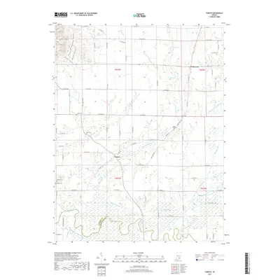
2019 Map of Tampico
USGS Topo · Published 2019About this map
Tampico and Dudleytown serve as the primary anchors for this southern Indiana landscape, where the gridded agricultural fields of Jackson County meet the winding course of the Muscatatuck River. The geography is defined by a sophisticated network of drainage systems like Smart Ditch and Cammie Thomas Ditch, which manage the low-lying terrain near the confluence of the Vernon Fork Muscatatuck River. These waterworks reflect the region's long-standing commitment to reclaiming fertile bottomlands for farming.
Find a feature on this map
70 named features on this map. Tap any name to fly to it.
Don’t see what you’re looking for? This feature index may not catch every label — zoom into the map to look around manually.
Map Details
Editions of this 2019 Tampico Map
This is the sole edition of this map. No revisions or reprints were ever made.
Other maps of this area

1947 · Scottsburg
USGS Topo · 1:24,000

1953 · Kossuth
USGS Topo · 1:24,000

1956 · Vincennes
USGS Topo · 1:250,000

1956 · Louisville
USGS Topo · 1:250,000

1957 · Vincennes
USGS Topo · 1:250,000

1958 · Vincennes
USGS Topo · 1:250,000

1958 · Little York
USGS Topo · 1:24,000

1958 · Brownstown
USGS Topo · 1:24,000

1958 · Seymour
USGS Topo · 1:24,000
1959 · Vallonia
USGS Topo · 1:24,000