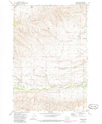
1971 Map of Tampico
USGS Topo · Published 1985About this map
Cowiche Mountain and Ahtanum Ridge frame this detailed landscape in Yakima County, illustrating the transition from steep high-desert slopes to the irrigated agricultural flats below. The settlement of Tampico sits at the convergence of the North Fork and South Fork Ahtanum Creek, serving as a gateway to the mountains where numerous corrals and jeep trails snake through Cowiche Basin.
Find a feature on this map
35 named features on this map. Tap any name to fly to it.
Don’t see what you’re looking for? This feature index may not catch every label — zoom into the map to look around manually.
Map Details
Editions of this 1971 Tampico Map
2 editions found
Other maps of this area

1899 · Ellensburg
USGS Topo · 1:125,000

1901 · Ellensburg
USGS Topo · 1:125,000

1937 · White Swan
USGS Topo · 1:125,000

1950 · Yakima
USGS Topo · 1:250,000

1957 · Yesmowit Canyon
USGS Topo · 1:24,000

1958 · Fort Simcoe
USGS Topo · 1:62,500

1958 · Wiley City
USGS Topo · 1:24,000

1958 · White Swan
USGS Topo · 1:24,000
1958 · Medicine Valley
USGS Topo · 1:24,000

1958 · Naches
USGS Topo · 1:24,000